


GROUND STUDIES
GEOPHYSICAL METHODS
During investigation of the soil or rock by traditional geological surveys there could be necessary to additional use geophysical surveys. However, a limitation of geological information is invasiveness and obtaining the data from drilling point. In contrast, engineering geophysical surveys allow for non-destructive recognition of the medium in continuous, fast and economic way. Such ground studies are widely used for many years to solve engineering problems in ground recognition tasks for design purposes. They are also used in an assessment of the reliability of the implementation of the investment and the monitoring of changes in the soil in time.
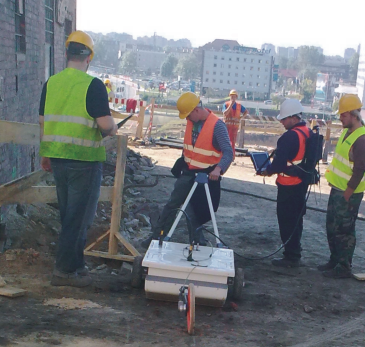
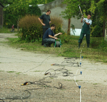
GPR acquisition to identify the structure of the soil, geotechnical borders and cracks in the rock during construction works (left) and seismic acquisition for geotechnical recognition before construction design phase (right)
Most often, the following geophysical methods are applied:
- georadar (GPR),
- seismic engineering,
- resistivity,
- gravimetry,
- elektromagnetics.
Such studies are an important supplement to geotechnical investigations for precise diagnosis of the structure and geomechanical condition of the ground.
RESISTIVITY METHOD
Geophysical ground studies using resistivity method base on changes in the resistivity of the ground, which is caused by natural or anthropogenic objects which differ in electrical parameters. Studies are performed using:
- resistivity tomography 2D – ERT,
- vertical sounding 1D – VES,
- profiling 1D – EP.
The final results are presented as vertical profiles, cross-sections and maps of the resistivity changes with the geophysical or geological – engineering interpretation.
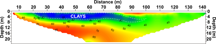
Resistivity studies to assess the thickness of the clays
SEISMIC METHOD
Geophysical surveys using seismic method base on changes in elastic parameters of the ground and are carried out using different techniques:
- refraction,
- multichannel analysis MASW,
- refraction tomography,
- crosshole tomography,
- downhole/uphole testing,
- crosshole testing.
The result of studies is to determine the seismic boundaries and calculation of seismic and geomechanical parameters. The results of seismic surveys are presented in the form of cross-sections and maps of seismic with geological – engineering interpretation.
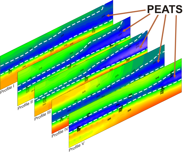
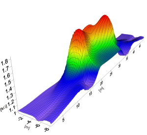
Seismic MASW sections present changes in the thickness of the layers and allow to determine the volume of peats
Seismic refraction tomography cross-section for the office building foundation project in the post-mining area. Surveys indicate high thickness variability of nearsurface layers and identify rock ground.
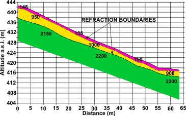
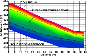
Seismic cross-sections: refraction (left), imaging the a three-layer construction of landslides and refraction tomography (right) with marked refraction boundaries. Visible additional boundary of the solid flysch bedrock and variability of geomechanical state in rock massif.
GEORADAR METHOD
The basis of geophysical surveys using georadar method (GPR) are changes of electric parameters of tested ground. They imagine the structure of the ground in detail up to tens meters in depth. Surveys for ground identification are done by profiling technique. Results are presented as depth cross-sections, including geophysical or geological interpretation.
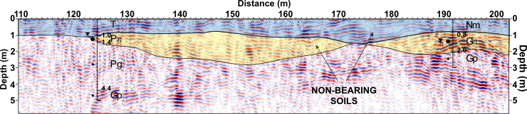
GPR cross-section of the ground with geophysical interpretation which was correlated with geotechnical surveys. The measurement was conducted in order to accurate detecting non-bearing soil borders for designed production hall
GEOTECHNICAL STUDIES
Geotechnical surveys allow to make (at points) an assessment of structure and ground conditions using:
- calculations of stability, More…
- test drillings and probing,
- in situ and laboratory studies.
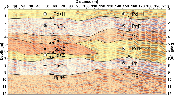
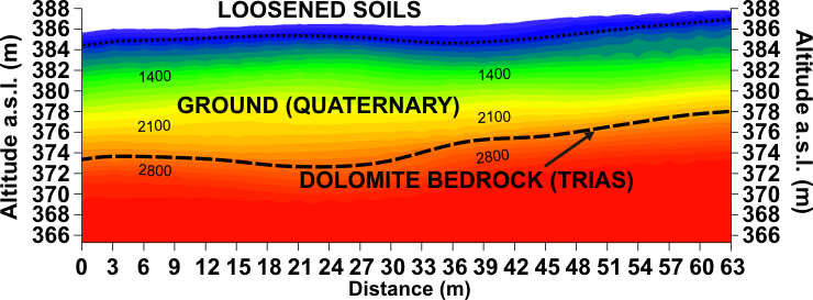
Geological and engineering cross-section on the GPR image
Geotechnical cross-section on the GPR image
ADVANTAGES OF GEOPHYSICS
- non-destructive & non-intrusive,
- continuous,
- mobile,
- time&cost saving,
- preliminary assessment in the field,
- optimization of the design and carrying out of geological works,
- ability to perform geophysical works at any season, regardless of weather conditions,
- the possibility of geophysical monitoring in time.
CAPABILITIES
Geophysical studies are applied to detection and determining:
- geological boundaries, weathering zones and depth to bedrock,
- sinkholes, voids, karst, caverns,
- faults, fracture & weak zones,
- groundwater levels,
- rippability,
- underground objects,
- analysis of changes in compaction, subsidence, slip surfaces,
- geomechnical parameters like dynamic elastic modules: Young – Emax, shear – Gmax, bulk – Kmax, dynamic Poisson’s ratio.
SELECTED APPLICATIONS OF GEOPHYSICAL METHODS
- communication tunnels projects, highways, roads, rail-roads and their monitoring,
- pipeline, HDD horizontal directional drilling, DD directional drilling & Direct Pipe planning,
- analysis of the causes of damage to roads and communication infrastructure and construction disasters, More…
- foundation of large buildings and hydrotechnical constructions, More…
- foundation facilities generating large vibration and dynamic loads (wind power turbines on wind farms), More…
- detection of voids, discontinuous deformations, channels, tunnels, More…
- stability assessment of landslides, slopes, levees and embankments. More…


