


SURFACE DIAGNOSTICS
NON-INVASIVE GEORADAR SURVEYS
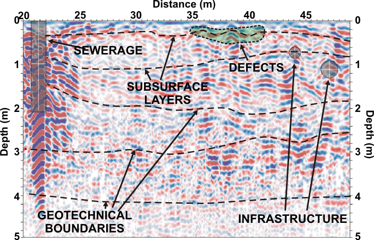
Dynamic technological development in recent years had crucial impact on the prevalence of the usage of the geophysical techniques. Problematic aspects of surface diagnostics commonly use non-invasive georadar surveys (GPR). They allow to carry out rapid and effective assessment of the technical surface as well as substructure state for runways, airport parking plates, highways, roads, bridges, rail-roads etc. Such surveys provide continuous and non-invasive detailed information about ground structure in order to describe continuity of geotechnical boundaries and occurrence of defects in constructing layers.


Georadar survey of the pavement (left) and at airport runway (right)
ADVANTAGES OF GEORADAR
- non-destructing (non-invasive) surveys,
- high accuracy (about cm),
- continuous identification of the ground,
- high efficiency,
- relatively low cost of survey implementation,
- the speed of the surveys,
- possibility of measurements in different field and atmospheric conditions,
- preliminary assessment already in the field,
- optimization of geotechnical investigations and repair works.
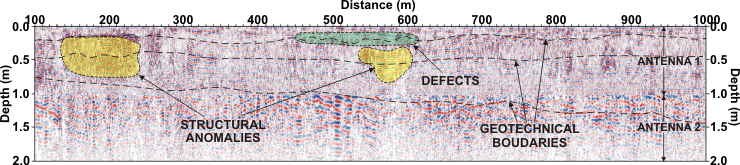
An example of georadar cross-section of the asphalt road surface along the lane with applied geophysical interpretation. The survey was done with two antennas which have different depth of penetration and vertical resolution
HIGH-RESOLUTION ANALYSIS OF SURFACE STRUCTURE
In many engineering tasks, it is very often important to proper determine the structure of surface in a very precise way. In such cases it is necessary to recognize thickness’s of structural layers (layers of asphalt, concrete, stone, paving, etc.). What is important, precise verification of occurrence and proper location of connecting or reinforcing elements such and bolt anchors is also expected. Such studies are increasingly demanded by investors at the stage of verification of compliance with the designed scope of construction works. GPR surveys are predestined for these tasks. It is always better to identify source of the problem when faults are detected in non-destructive way at the end of construction phase. The requirements, which are then faced before engineering, can only be met by using high-resolution (HR) GPR antennas.

Georadar acquisition using high resolution bipolar antenna on the road surface made of porphyry slabs
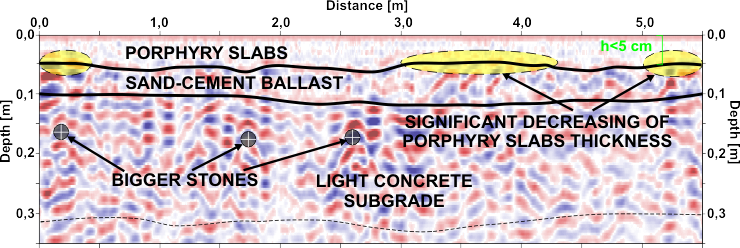
A sample of georadar cross-section on the road surface covered with porphyry slabs, with geophysical interpretation. The measurement was carried out using very high resolution antenna
Such antennas must be characterized by a very high vertical resolution (~1 cm) which can be met through specialized antenna with minimum of 2 GHz or higher dominant frequencies. However, such accurate studies carry the risk of the impact of small, disrupting objects (small tubes, stones, cables, small irregularities of surface) for data logging. Very often HR GPR bipolar antenna sets are applied.
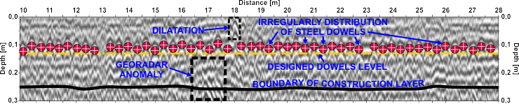
A sample GPR cross-section for the surface of the motorway made of concrete slabs densely joined by steel dowels. Derogations in depth and placement of dowels are clearly indicated. Additionally georadar anomalies and boundary between layers were determined.
GPR investigation results should be verified by mechanical geotechnical boreholes, which clearly find the cause of the detected georadar anomalies. Drillings will specify the scale of unfavourable processes. Proper and early diagnosis allows for quick application of appropriate repair work.


Mechanical drilling in concrete layers on highway, located in place of observed and marked cracks on surface (left) and a core of two outer layers of concrete separated by a geotextile, with a visible long vertical crack in top layer (right)
Prior to the implementation of GPR studies, very important is the selection of appropriate antennas, depending on the goal and required results. Applying for such cases, georadar antennas with inappropriate frequencies leads to unacceptable errors in precision of identifying of location, depth, thickness, or even inclination of structural objects such as steel anchors, dowels, reinforcement meshes and etc. The real relative position between these elements can be found as well.
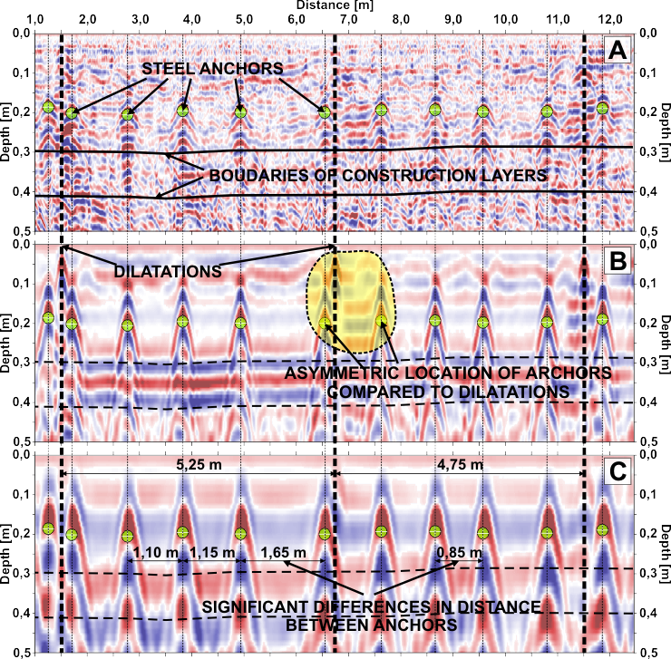
GPR cross-sections using antennas different frequencies (resolutions) on concrete surface reinforced by steel anchors. Fig. A – antenna with the highest resolution. Fig. C – antenna with the lowest resolution. Visible numerous derogations in the positioning of the anchors and the differences in the location’s precision of structural objects
APPLICATIONS
- identification of the continuity of the concrete slabs and bituminous layers,
- assessment of thickness when there are many layers of foundation,
- identification of voids, stand out zones, cracks and crevices,
- localization of flux, washouts and suffosion under the surface,
- compaction and subsidence mapping,
- identification of reinforced slabs and pipes, ducts, conduits, drains etc.,
- analysis of the lithological system,
- elaboration of geotechnical investigations to recognize the geomechanical state and structure,
- monitoring of the changes in ground while surface and subsurface layers exploited,
- determination of foundation layers mixing.

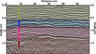
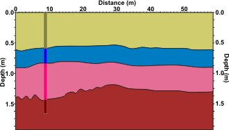
Core sample from geotechnical investigation done in a road (left). An example of georadar cross-section of the asphalt road surface done along the lane with applied geophysical interpretation correlated with geotechnical investigations (middle) and geotechnical result of the correlation (right).
Georadar cross-section across the runway with applied geophysical interpretation

Georadar cross-section along the airport taxi way with applied geophysical interpretation


