


STABILITY ANALYSIS
PROBLEMS OF LANDSLIDES ON SLOPES
The Earth’s surface is constantly changing, especially in the most subsurface zone as a result of geological and atmospheric processes. An additional and very important factor is human activity such as groundworks and construction works. They are manifested by undercutting slopes, regulation of river beds, designing transport infrastructure through inclined areas, construction embankments, dams, flood embankments. Adverse weather conditions, excessive static and dynamic loads may cause that these objects will slide and be damaged.
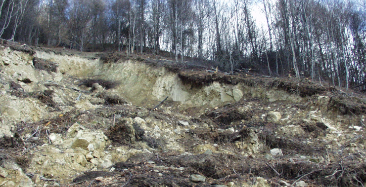
The slope with significant landslide movements, below which there is a municipal road
Stability analysis as a comprehensive determination of the equilibrium state of all natural and anthropogenic slopes requires consideration of many factors. In the field of landslide movements the most important is the detailed identification of the soil and rock center. It is carried out through geotechnical and geophysical surveys. Their scope is adjusted to the complexity of the problem.

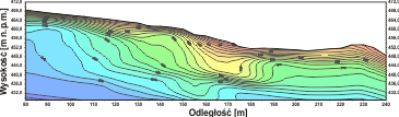
Seismic survey on a slope next to the road for more accurate determination of lithological boundaries
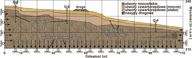
Computational model with boundary and initial conditions for the stability analysis of the slope with the asphalt road across. Seismic survey were used to determine the geotechnical boundaries
FACTOR OF SAFETY F
Solution of the stability analysis is to calculate the safety factor F for the given geometry of the slope and its geological structure using mathematical methods. The boundary condition for this factor is assumed to be 1 (values above this limit are considered to be stable). This parameter is determined for the weakest potential slip plane in the tested slope. It is not a two-variant classification. There are a number of more complex classifications, which are chosen to particular issues.
During the calculations, various methods are used to determine the potential slip planes, along with their safety factor. Correct selection of the calculation method provides an approximate stability assessment for the given boundary and initial conditions of the calculation model.
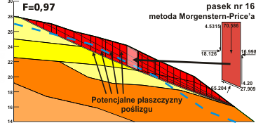
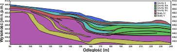
The computational model created from the geological-engineering cross-section of the slope (at the top) and distribution of potential slip planes for analytical-strip method according to the Morgenstern-Price calculation scheme (at the bottom). The weakest slip plane has a factor of safety F=0,97.
ANALYTICAL METHOD
The calculation scheme of the analytical method is based on the strip method where the slope is divided into parallel vertical stripes. Their width is determined according to the geological structure and topography of the area. Stability calculations are performed on the basis of mutual interactions of individual strips on each other according to various analytical methods, such as Morgenstern-Price, Bishop, Janbu or others.
Stripe methods are suitable for simple geological conditions where the planes of slip do not have a complicated trajectory. The planes are determined individually and separately for each of them.
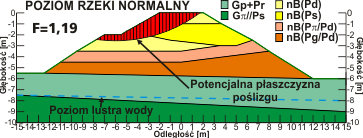
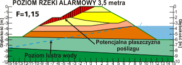
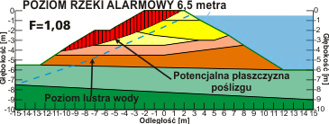
The computational model for levee. Stability factor decreases with the level of water transgression from the riverbed.

An example of a stability analysis for a slope near a railway for a planned repair of a railway embankment
NUMERIC METHOD
More advanced method of the stability analysis is the numeric method. Unlike the strip methods, during numerical calculations the model is covered with an appropriately dense mesh. The force distribution is calculated for each mesh node. Such algorithms are performed by e.g. the finite difference method FDM or finite element FEM.
Advantages of numeric methods:
- determining many slip planes at the same time
- better accuracy of calculations
- recommended for complex geological conditions
- possibility to make detailed dynamic, thermal and hydrogeological analyses
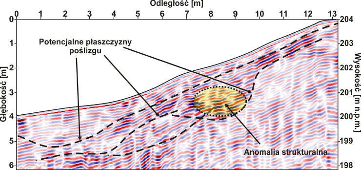
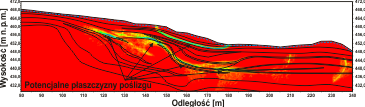
Georadar cross-section made on the hillside to determine potential slip planes need for factor of safety calculation. The whole system of slip planes on landslide was detected.
2D seismic refraction tomography cross-section (left) on the basis of which together with the borehole data a computational model consisting of geotechnical layers was created (top right). Then using the numerical method the distribution of forces in the medium was calculated, presented in the cross-section which shows potential slip planes (bottom right).
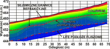
Comparison of seismic cross-sections: classic refraction surveys (on the left) and refraction tomography (below) on a landslide in Carpathian flysch. The solid flysch bedrock was defined only due to usage of tomography, while refraction provides information from shallower parts of the ground.
APPLICATIONS FOR STABILITY CALCULATIONS
- levees, barriers, dams with various levels of water
- slopes, hillsides at various atmospheric conditions
- road and railway embankment various load variants
- safety projects of landslides
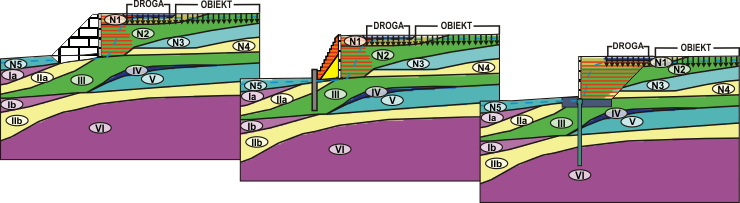
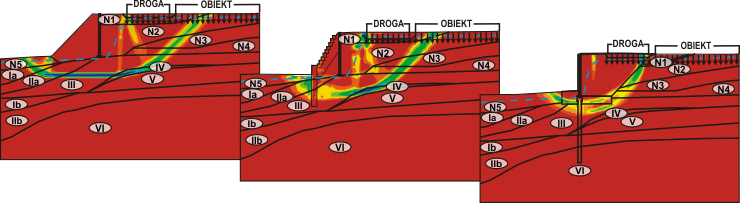
Calculations of the stability of the slope below the road. The analysis consisted in checking various methods of protection of the slope affected by a static load in the form of a road and an object located nearby. The distribution of geotechnical layers is based on geotechnical boreholes and seismic surveys (at the top). The results of the stability analysis together with the marked boundaries of the geotechnical layers and the slope protection (at the bottom) show differences in the shear deformation distribution and thus changes in the shape and range of potential slip planes depending on the slope protection used in the calculations.


