


MINING AND GEOLOGY
GEOPHYSICS IN MINING AND IN POSTMINING AREAS
From many years geophysical surveys are commonly used to solve problems related to exploration and exploitation of mineral deposits, both on the ground surface (open pit mines) and below the ground surface (underground mines).
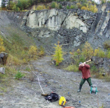
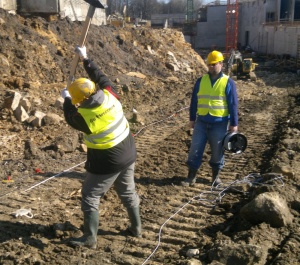
Engineering seismic surveys to determine the thickness of the weathered layer in sandstone quarry (left) and microgravimetric survey to locate the wandering voids being the result of shallow mining (right)
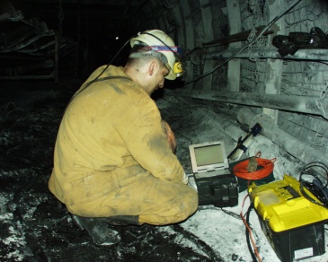
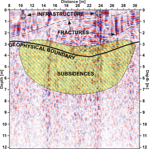
Seismic measurements to assess the risk of rockburst in hardcoal mine (left) and georadar profiling for the determination of shear planes in the ground in the former hard coal mine area (right)
Most commonly used geophysical methods in mining and geology: seismic method, microgravimetric method,
DC electrical resistivity method and georadar method (GPR).
Above geophysical surveys are used to identify and to determine:
- changes in the thickness of overburden and to bedrock determination for the exploitation of near-surface deposits,
- continuity and disturbance of the structure in seams with cracks and fractures,
- contact zones between e.g. salts and anhydrites,
- spatial geological structure of overlying layers and deposits – deposit contouring,
- prospective zones for optimal exploitation of the mineral resources,
- rockburst risk,
- underground „migrating voids” in post-mining areas,
- undocumented and unliquidated mine excavations,
- loosened ground and „weak zones”.
SEISMIC SURVEYS
Geophysical surveys that use seismic method base on the variation of density and elastic properties of tested ground. In the mining and geology this method is ideal for location voids, cracks zones in the ground and effectiveness of backfill in shallow mining areas. It is commonly used to determine the depth and continuity of solid bedrock, to estimate cracks anisotropy, rocks rippability for exploitation at open pit mines and also for calculations of dynamic elastic modules and initial assessment of geomechanical classes e.g. for tunnel construction.
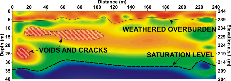
Results of MASW 2D surveys carried out for detecting and contouring voids, loosened zones, cracks and subsidences under the road surface
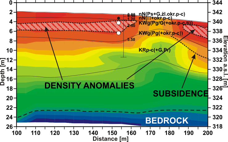
P-wave velocity field as a result of seismic surveys done by refraction tomography method to determine the loosened zones and cracks. Ranges of landslide risk areas are marked basing on georadar boundaries. Indicated probable fault zone was confirmed by geotechnical surveys
GRAVIMETRIC SURVEYS
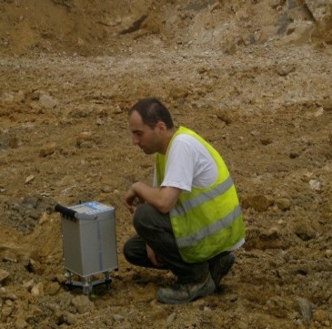
Geophysical gravimetric method base on the variation of gravitational field of the Earth. Application of engineering version called microgravimetry gives particularly good results in the location of abandoned wells, shafts, adits, headways, detection of voids, occurring in the subsurface along with forecasting their expansion towards the surface of the ground. These objects can generate the surface discontinuous deformation of surface creating shell-pits and sinkholes. In the areas of occurrence of such voids, cracks and loosened zones are generated negative gravity anomalies. Microgravimetric observations at the measurement points are carried out using Autograv CG-5 gravimeters. The results of the surveys are presented as maps of the distribution of gravity anomalies in the Bouguer reduction and also residual anomalies.
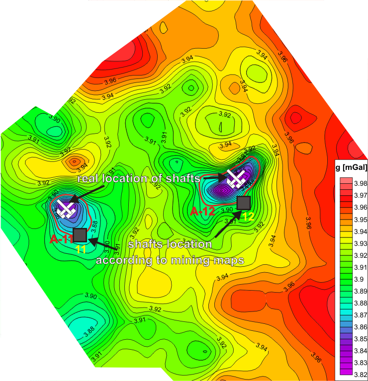
Map of gravity anomalies in Bouguer reduction on the basis of microgravimetric surveys
Gravimetric surveys are also carried out in larger scale to locate and determine surface range of fuel and mineral deposits. Thanks to these surveys it is possible to determine structural oil and gas traps, salt domes and surface range of deposits. Results are presented as maps of gravimetric anomalies.
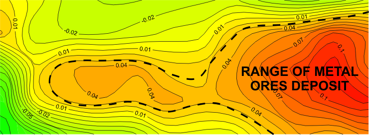
Regional surface gravimetric image for exploration of raw materials deposits
DC ELECTRICAL RESISTIVITY SURVEYS
Geophysical surveys made by electrical resistivity (geoelectric) method base on the detection of rocks and other underground objects characterized by different electrical properties. Such surveys in mining and geology are performed to locate geological boundaries, detect and map geologic features, identify postmining areas, determining aquifers areas. After interpretation and corelation with geotechnical informations, it is possible to identify zones of voids, cracks zones, contamination, delineate aggregate deposits in quarries etc.
Results of electrical resistivity tomography ERT 2D in the area of historical hardcoal mining
GEORADAR SURVEYS
Application of georadar method (GPR) in the open pit mine and underground mine areas, taking into account its limitations, primarily helps in determination of structure of the investigated ground or rock massif. Typical GPR applications are: deter-mination of fracture zones, delinea-ting geophysical boundaries which after correlations with geotechnical boreholes allow to detect disconti-nuities in the structure and lithology.
In addition, positive side effect of georadar surveys, where high vertical resolution antennas are used is detection and location near-surface infrastructure of the mine (very often not having sufficiently detailed course). By using a dense grid of transverse and longitudinal acqui-sition profiles, it is possible to contour anomalies much more precisely. After that there is many differend tech-niques of processing and inter-pretation, which can be selected, depending on the quality of recorded GPR signal.
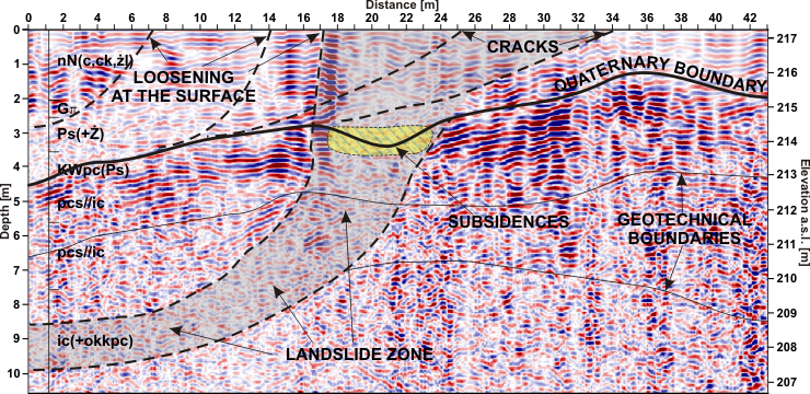
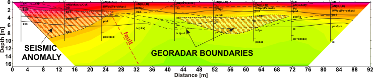
Depth GPR cross-section on the edge of slope of open pit coal mine, for determining the range of landslide zone. There was also detected rupture of soil-rock massif in places where loosenings and cracks on the surface were observed


