


Main Page | Knowledge base | Geophysics | Georadar
GEORADAR
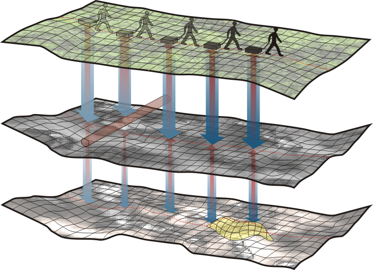
The principle of operation of GPR is generating and sending an electromagnetic wave into examined soil, rock or other material. This is done by transmitting antenna generates a signal of a specific frequency. Wave passed through the soil is refracted, reflected on the geotechnical borders, when encountering facilities, infrastructure or other inhomogeneities wave is dispersed, called diffraction. Both antennas are connected to the control unit, which manages the generation of the reflected wave and the digital recording. GPR signal is triggered by measuring device mounted on wheels. When moving along the profile control unit stores separate traces of signal, which create cross-section called radarograms. Depending on the character of the research work there is two techniques of interpretation.
GPR profiling
When surveys are made along separate single profiles, which are lines marked out in the field. This technique is usually used, for example, for the purpose of geological or geotechnical exploration. GPR sections are used to interpret geological-engineering research and correlate with informations from geotechnical drilling. Similarly, in the case of search facilities or infrastructure inventory, the result shows a georadar cross-section of soil directly under the assigned in the field profile.
GPR mapping
When surveys are made to create horizontal slices on different depths. There are performed a series of parallel profiles which, when assembled into a solid geometric 3D image of measured soil. This technique is used for archaeological, detecting of fouling or leaks jobs. It is well suited for detection of underground infrastructure networks, as the result of the mapping, which is a result of interpolation between neighbour GPR profiles. This makes it easier to recognize the larger and irregular objects. Unlike profiling, mapping allows you to specify more precisely the course of the walls of the underground installations, by applying the results of georadar research onto contemporary location maps.

The accuracy and range of GPR method depends primarily on the frequency of the emitted electromagnetic signal, which ranges from 10 MHz to several GHz. Such a frequency range causes the range of GPR method varies from a few centimeters to tens of meters. Resolution, which is the expected vertical accuracy of studies varies from a few millimeters to a few meters. Dependency resolution and range are inversely proportional, which means that the higher the frequency of the generated wave increases resolution, but the range decreases.
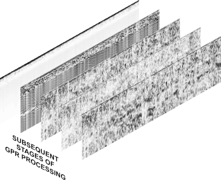
GPR data obtained from field work requires the processing. This is done using specialized geophysical software. Disruptions from objects located in close proximity to the measurement are removed during that. The signal is subjected to several filtering procedures and sharper amplitude is applied. At the end of processing the signal is subjected to a transformation from the time domain to the depth domain.
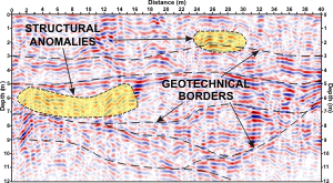
Processed in such a way georadar section is interpreted together with eventual other geophysical and geotechnical informations. Type of the interpretation depends on the expected parameters and it is adjusted to different jobs like searching facilities, location of underground objects or geological and mining issues. GPR as a geophysical method is the most common engineering studies for the shallowest jobs.
Examples of use GPR method:
- Mapping of underground utility networks (plastic PE-HDPE-PVC, metal, concrete, etc.),
- Objects location such as the mining voids and karst, tunnels, shallow excavations: shafts, walkways and other underground structures (chambers, collectors, tanks, concrete slabs and columns, foundations, piles, etc.). More…
- Cables and pipelines planning and maintaining,
- Detection of unexploded ordnance,
- The study of structures of bridges, viaducts, ceilings and walls,
- Diagnosis of surface and ground: roads, highways, railways (for the revitalization and modernization of railway lines), airports. More…
- Evaluate the distribution of primer layers like gravel, etc. More…
- Detection of sinkholes and subsidence. More…
- Classification of ground stratification and segmentation deposits. More…
- Recognition of structure and its condition of railway railroad bed and ground,
- Recognition of the ground for planned and existing transport infrastructure such as roads, highways, ring roads,
- Analysis of the position of the water tables,
- Shallow lithological and stratigraphic analysis. More…
- Characteristic of system fractures of rocks and concrete,
- Mapping crypts, sarcophagi, tombs, graves,
- Support for archaeological works,
- Examination of industrial and contaminated sites.


