


Main Page | Knowledge base | Geophysics | Georadar | GPR mapping
GPR MAPPING
GPR mapping is an advanced method of interpretation, where in addition to the classical interpretation GPR profiling, performs an interpolated summary of the many GPR sections. This is very important to determine their geometry to replicate as closely as possible the actual location for each profile in the field. For this purpose it can be used a precision GPS receiver. Usually parallel profiles or mesh of profiles (transverse and longitudinal) are applied for more precise scanning of the medium. The distance between the parallel profiles or the mesh size is chosen individually according to each job.
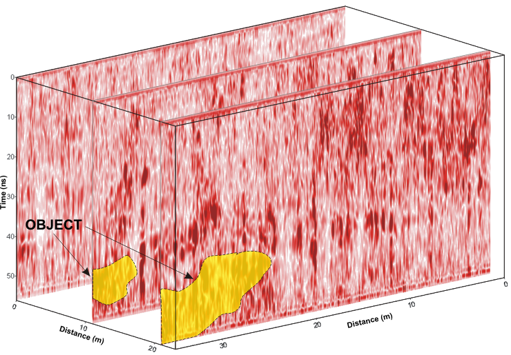
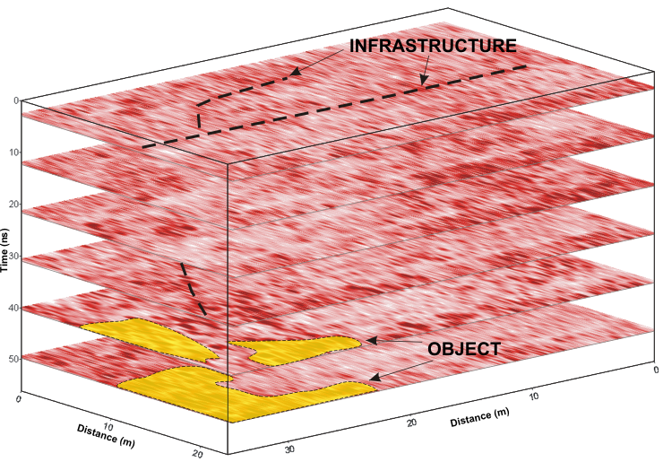
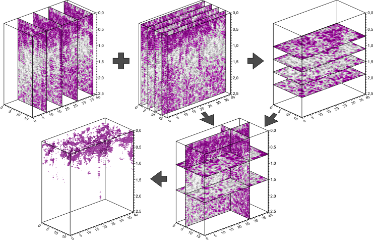
The next step is processing, where there is constructed 3D structure model of the medium. Empty spaces between profiles are filled with interpolated samples of data from neighbouring records, so it is important to appropriately dense land cover by GPR profiles. After such a comparison in the form of 3D profiles there is possible to make maps of GPR signal at any depth and cross-sections in any direction. This geophysical method is extremely helpful in the analysis of the scans in the different angles. Through this course of underground infrastructure, reinforcement or other linear object is visible in the form of increased signal amplitudes and put in solid lines.
Among all the geophysical methods, GPR survey is the most interesting proposition for infrastructure inventory. Proper selection of frequency and optimized measurement methodology allows to achieve amazing results, and with additional data from geotechnical studies, mapping is an excellent tool for shallow engineering geophysics and for the diagnosis structure of the medium.
Examples of application of the georadar method using GPR mapping:
- Mapping of underground utilities networks (plastic / PE-HDPE-PVC /, metal, reinforced concrete, etc.),
- Location of objects, such as tunnels, shallow excavations (shafts, mine roadways and other types of underground structures like chambers, collectors, tanks, concrete slabs and columns, foundations, piles, etc.). More…
- Planning and maintenance of cable and pipeline,
- Examination of the structures of bridges, viaducts, ceilings and walls,
- Detection of sinkholes and subsidence. More…
- Analysis of the position of the water table,
- Characteristics of system cracks in rocks and concrete,
- Mapping crypts, sarcophagi, tombs, burial places,
- Support for archaeological work,
- Study of industrial sites and contaminated,
- Exploration of buried corpses and victims of mass murders such as the World War II.
“Project co-financed by the European Union under the Malopolska Regional Operational Programme for the years 2007 -2013 co-financed by the European Regional Development Fund”


