

Main Page | Knowledge base | Geophysics | Resistivity surveys
RESISTIVITY SURVEYS
Geophysical surveys, which use geoelectrical methods base on the variation of electrical parameters of the soil. To understand the phenomena in ground-rock medium, in which electric current flows, it must be realized that such substrate resists while electric current flows through it. According to Ohm’s Law, resistance R is directly proportional to applied voltage U and inversely proportional to current intensity I. Basic parameter which is calculated using geoelectrical methods is electrical resistivity of the soil. Therefore, geoelectrical methods are equated with electrical resistivity methods. Resistivity is the property of material and on its basis we are able to characterize the ground below the surface.
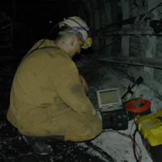
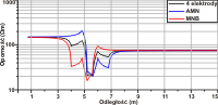
The essence of electrical resistivity surveys is the flow of current of known intensity I from current electrodes (AB) to electrodes (MN) that measure potential (potential electrodes). It results in difference of potentials and the voltage U allows to determine the electrical resistivity of the ground. However determined resistivity in field (in situ), is so-called apparent resistivity which depends on the actual resistivities of individual layers of the ground.
Depending on the purpose of the survey there are carried out three types of acquisitions:
vertical electrical soundings 1D (VES)
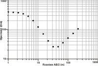
(PSE, SGE,VES) – Current electrodes are relegated from the potential electrodes in subsequent steps. Increasing the distance between current electrodes results in increased depth the are the larger the depth of investigation is. Depending on terrain and geological conditions it could be used different array spreads. This method is suitable for tracking the vertical changes e.g. variations in thickness of the layers and their continuity.
electrical profiling 1D (EP)
(PE) – The whole array is moved along the profile with unchanged geometry of the array. The assumption in this method is constant depth of investigation. This method is suitable for tracking horizontal changes in the ground e.g. different types of domes, vertical pinch out, dislocation zones, sincines, anticlines…
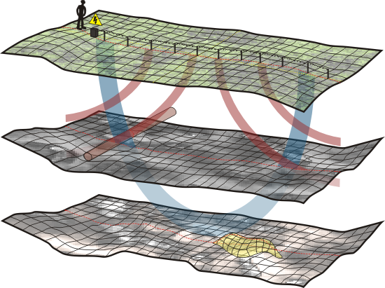
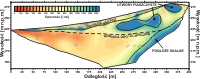
resistivity tomography 2D
(ERT, resistivity imaging) – This method is combination of electrical sounding and profiling. This method gives the best results and its another advantage is the short time of measurement.
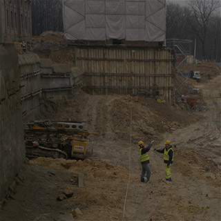
Selection of a particular methodology and measuring system depends on the local geological structure of the object and its location.
The final result is the geological-geophysical interpretation of engineering studies.
Resistivity method (geoelectric) using the above technique is commonly used to:
- determine the ground and water conditions, More…
- recognition of the geological structure in order to locate the areas of occurrence of groundwater,
- post-minig voids location,
- control the effectiveness of backfilling of voids and loosened the ground in areas of shallow mining,
- location of the water table, aquifers and groundwater,
- faults location,
- determine the areas of hydraulic breaks in flood embankments,
- determine the range of mineral and rock deposits,
- range of detection of contamination / pollution of soil and groundwater,
- determine the boundaries between freshwater and saltwater,
- determining the direction, speed and volume flow of water,
- determining the location of the prospective areas of shots and well boreholes in aquifers,
- location of buried metal objects,
- archaeological studies.